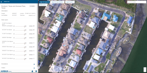
Photo, courtesy of Airbus Aerial.
Airbus Aerial, is already providing a fusion of drones, manned aircraft and satellite surveillance data to support two of the most powerful hurricanes to impact the U.S. and surrounding regions in recent history. Avionics recently caught up with Airbus Aerial President Jesse Kallman to discuss its latest activities including support for Hurricane Harvey and Irma.
Launched in May, Airbus Aerial is the new commercial drone services division of Airbus, one of several of its Silicon Valley-focused divisions. According to Kallman, the response it’s providing to the two Hurricanes is one of the first occurrences in aviation where drones, manned aircraft and satellite data are being combined to give a clearer overall image of specific locations before and after an incident. The company is providing what it calls “first-of-its-kind” imaging to insurers processing claims in Texas for free in order to provide assistance for survivors of Harvey effectively and quickly, and adequately prepare for Irma.
“While aerial images have been around for a while, collecting such images of a specific area viewed from the ground level, up to space and then turning it into actionable information has never been done before,” said Kallman. “We are hopeful that it will change the way disaster recovery is done in the future.”
One of the biggest services that Airbus Aerial provided in response to the impact of both hurricanes was high-resolution imagery, mapping and pinpointing of damaged areas for insurance companies. While it was not flying typical commercial Airbus aircraft over damaged areas, the company did work with partners in the affected regions to fly drones and single-engine aircraft at lower altitudes to scan impacted areas.
Using a combination of aircraft sensing equipment, satellite data and drone imagery that is fused into a simple-to-use cloud-based platform, Airbus Aerial was able to help insurance companies act faster on expected claims coming in from homeowners.
“That’s the core of what our business is bringing together drones manned aircraft satellites, any means of aerial data collection into one common service,” said Kallman.
“For example, we did flood-modeling analysis and overlaid that with where policy holders were so they could identify clusters of policy holders whose homes have been flooded and having that information they can start the insurance claim process before the claim is even made,” he said.
Kallman, whose career includes stints as an engineer at Northrop Grumman and director of customer engagement for commercial UAS aerial information provider Airware, said Airbus Aerial is also working in a support role for areas impacted by Hurricane Irma. For example, its team used Airbus radar satellites capable of seeing through clouds to detect areas where flooding could potentially occur to provide warnings for state officials and potential victims in areas of along the southern coast of Florida.
The commercial drone services division sees some of its biggest clients being state transportation departments and other agencies that require quick access to high resolution of critical infrastructure to gain a broad understanding of areas that need service or repairs.
One of its future goals is to support cargo drone services. Although Kallman, an unmanned aircraft industry veteran, sees several years before cargo drone services will becoming a widespread reality, there is already ongoing evaluation for such activity. According to Kallman, Airbus is participating in evaluation of the use of drones for transporting small packages around the National University of Singapore. An initial trial to evaluate the effectiveness of drones for mail delivery is already underway, he said.
What Airbus Aerial won’t be doing, though, is manufacturing drones, said Kallman.
“We’re 100% focused on services. We do not plan to manufacture any aircraft, we view drones as a tool to do certain jobs,” said Kallman.