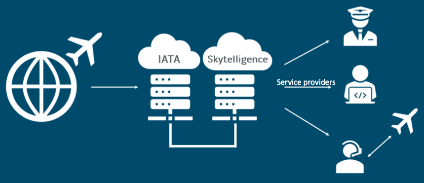
SmoothSky uses the International Air Transport Association’s (IATA) Turbulence Aware Program crowdsourced anonymized data and then the data is put into SmartSky’s Skytelligence, which is their web platform for trusted information sharing in the aviation ecosystem. (SmartSky)
During the Connected Aviation Intelligence program Brit Wanick, vice president of digital solutions at SmartSky, spoke about SmoothSky, the company’s new real-time turbulence data service for business aviation. SmoothSky helps operators improve safety, efficiency, and user experience during flights.
“The goal, ideally, is that you’d have a dynamic map with you much like we have a Waze in the car today,” Wanick said. “We know when we’re going to come upon an accident, and we can make adjustments. We need something similar in the airspace and that begins with having objective data to be able to work with and a key element of that objective data is real-time turbulence and the ability to display in the cockpit so that we can take action, and have that action be based on real-time objective observations that are occurring so that we can get from point A to point B safely.”
SmoothSky uses the International Air Transport Association’s (IATA) Turbulence Aware Program crowdsourced anonymized data and then the data is put into SmartSky’s Skytelligence, which is their web platform for trusted information sharing in the aviation ecosystem, Wanick said. The data is then transferred through application programming interfaces to web-based aviation apps used by pilots, operations centers, and managers.
Turbulence Aware is a tool created by IATA that uses an algorithm developed by the National Center for Atmospheric Research (NCAR) capable of collecting turbulence parameters from aircraft systems and sensors, aggregating that data and making it available in a raw format to participating airlines. Now, SmartSky is bringing the same capabilities to business aviation operators.
“So, our enrichment of it is to put it in a format that is most usable by the ecosystem of participants that we expect would need it, everything from a pilot to a web developer to a dispatcher,” Wanick said.
Wanick said SmartSky did not produce its own application for SmoothSky because there are already many options on the market, and they found the best approach to be formatting the information so that it can be used with applications users already had like an electronic flight bag (EFB) flight planning or weather awareness app.
SmoothSky is intended to be a real-time program, Wanick said. If turbulence is detected in an area, the program will report at one-minute intervals, if there is not turbulence detected, the program will report every 15-20 minutes. SmartSky was able to generate data, process the algorithm, and put the data in a display in less than five minutes during their Turbulence Aware testing process.
“If you had a trajectory path management capability that we’re able to pull into turbulence data and make adjustments, it’d be a lot like Waze, right,” Wanick said. “There’s an accident up ahead, in this case, there’s turbulence up ahead, on my plan path has now been reported, I want to make a change. It can provide alternatives you’d help provide a smooth ride throughout the event, allows you to essentially take advantage of better planning and arrival times.”
Wanick said SmoothSky will not only make flights safer by allowing route adjustments to avoid turbulence and severe weather, but it will improve operations by reducing potential aircraft damage and saving fuel with improved routing. It can also improve passengers’ onboard experience.
To make sure they had adequate coverage data for business aviation SmartSky coordinated with IATA to map standard flights on the East Coast, West Coast, and cross-country for turbulence reporting over the last year, Wanick said. His team also used various flight levels to gain a full scope of the data and coverage area